|
|
|
|
|
|
|
|
|
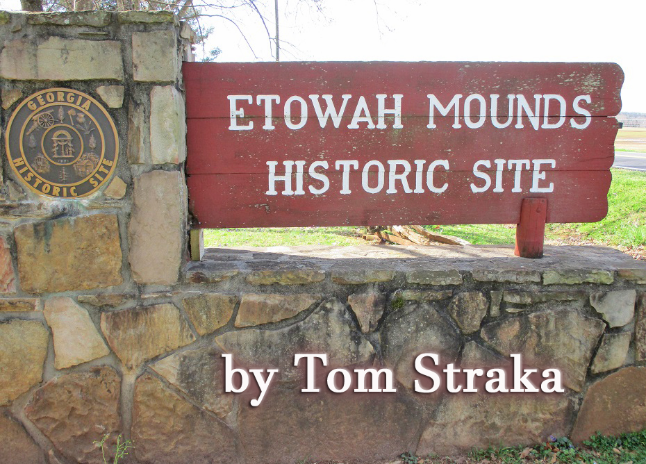
Good pandemic travel destinations need to be interesting, generally not crowded, and preferably mostly out-of-doors. Etowah Indian Mounds just off Interstate 75 north of Atlanta near Cartersville, Georgia meets that definition. It includes a small museum with a huge outdoor expanse which was the largest Native American settlement in the Etowah Valley. Still remaining are historic Indian mounds on the north bank of the Etowah River. Etowah Mounds State Historic Site claims to be the most intact
Mississippian Culture site in the Southeast. It is a 54-acre
historic landscape which drew Native Americans to a location
which included a ceremonial complex of ritual and burial
mounds. The site was occupied from about 900 A.D. to 1550 A.D.
and the population reached several thousand Native Americans.
Walking across the site to view the six earthen mounds, you
will encounter borrow pits, a defensive ditch, the village
site, and a plaza. Mounds A, B, and C are the most prominent
and interesting ones. The museum is full of wood, seashell, and stone artifacts that
illustrate the political and religious nature of the site. The
natives decorated themselves with paint, shell beads,
intricate hairdos, feathers, and copper ear ornaments. A
highlight is125-pound hand-carved effigies that still bear
some original pigments. The mounds are adjacent to the Etowah
River and a V-shaped fish trap of the type used by the natives
is visible on the river. The trail through the site includes
descriptions of native trees were used for food and medicine.
Some History Signage calls it a “chiefly village.” Its population and size
increased and decreased over its 600 years of occupation.
Village residents supplied the labor that supported the
society’s elite. They raised crops, hunted and fished, built
mounds and palisades, made tools, baskets, and pottery,
prepared hides, cooked, trained their children, traded with
other villages, played games of chunkey, celebrated the
seasons, and worshiped their gods. Many were trained to carry
out specific tasks such as the production of chipped or ground
stone tools. Others created beautiful hide garments or the
copper ornaments worn by Etowah’s elite. At times, disease, famine, drought, floods, fires harsh
winters, seasonal storms, and regional warfare drove the
people from the village. Yet, they always returned because of
its ceremonial importance and its status as an ancient
capital. After A.D. 1550, Etowah’s occupants moved down river
along the Coosa River in Alabama. Some researchers believe the
arrival of Europeans caused this social disruption. It is
well-documented that European diseases, such as measles and
smallpox, decimated many native populations. By the time the
Etowah River Valley saw its first European settlers, the local
Cherokee Indians attributed the mounds to an ancient people
remembered only in their oral traditions. The de Soto expedition visited Etowah. In May 1539, Hernando
de Soto arrived on the west coast of Florida (near present day
Bradenton). With over 620 men and 220 horses, he journeyed
over the interior South for three years. In August 1540 his
army departed from the main Indian town of Coosa and traveled
to the south, crossing the Etowah River at the town of Itaba,
now called Etowah, before proceeding on to the chiefdom of
Ulibahali at present-day Rome, Georgia. At Etowah
archaeologists have unearthed several artifacts that date to
the period of de Soto’s travels, indicating his presence in
the area. What to Expect Etowah is a state historical site, and a historical marker is
at the entrance. A picnic area is located near the parking
lot. A Native American chief statue greets the visitors at the
museum entrance.
The site is worthy of a state historical marker
Native American Chief
You will start your visit at the museum where you pay a small
fee to enter. The museum has many displays of artifacts
discovered at the site, including Mississippian culture
pottery and stone statuary, monolithic stone axes, copper
jewelry, and shell beads. The culture is also discussed,
including trade networks, religious customs, games, diet, and
crafts.
Example of pottery artifact. 
One of dozens of displays.
The hand-carved human marble effigies discovered during the excavation of Mound C.
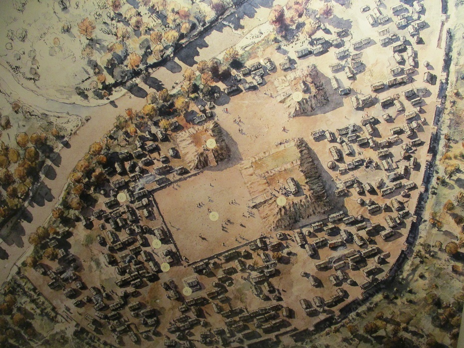
The feather headdress. The diorama and overview map below give an idea of the layout of the site. In the diorama, Mound A is the large one in the upper right, with the rectangular plaza extending in front of the staircase. To the left side of the plaza is Mound B and Mound C is in the upper left-hand corner. The overview map gives a better idea of what the entire site looked like.
Diorama of the mound sizes and locations.
Overview map showing entire village. As the visitors leave the museum for the trail to the mounds, one of the first encounters is a wattle and daub house, reminiscent of those that covered the site between 1250 and 1325 A.D. It was constructed using upright posts with woven green cane (wattle) between each. Volunteers applied daub or Georgia clay mixed with grass and water to cover the wattle. While some of Etowah’s structures were round, the majority built during Etowah’s most densely populated period were square. Close-by is part of the defensive ditch/borrow pit.
Visitors to the village were met by a prominent wall and
defensive ditch, demonstrating strength to approaching
enemies.
Etowah’s wattle and daub house.
: Part of the defensive ditch and borrow pit. Mound A is topped by a platform that provided the foundation for the great temple that housed the chief and his family. It stands about 65 feet tall with a base measuring 395-by-335 feet. From the top, the chief presided over ceremonies on the plaza below. While the plaza is difficult to discern from ground level, from the top its outline becomes visible. The outline of the ditch system is also visible from the top (it is marked by a modern fence). Of course, the staircase is modern and a ramp, projecting from the eastern side, provided access to the top. A smaller terrace is attached to the mound’s south side. Mound A has not been completely excavated.
Some perspective, the larger Mound A to the right of Mound B.
Mound A presents an imposing picture
.: Just as imposing is the ramp to the top of Mound A Mound B was also a temple platform and has never been completely excavated. Most likely a lessor chief or priest resided on top of Mound B. Mound C has been completely excavated and reconstructed. Most of the artifacts in the museum came from this mound, including the marble effigy statues. Mound C was a mortuary mound where many burials took place. The 350 burials unearthed in the mound told scientists much about burial and ceremonial practices, classes, dress, diet, diseases, and trade patterns of the natives.
Mound B from the top of Mound A.
Mound C, with the edge of Mound A’s southern terrace.
The Etowah River in spring, with the fish trap barely visible in the distance This is a perfect pandemic day trip. Most of the visit will be outside and the museum has wide aisles and a natural flow that keeps people apart. There is a lot of history, cultural and natural, to make for an interesting day. On some Saturdays educational programs are available (like Tools and Weapons Day or Skills of the Past Day). It is a historic site well worth a visit.
We'd love your comments!
|
American Roads
and | ||||||||||||||||||||||||||||||||||||||
|
Public Disclosure--
Please Read The FTC has a law requiring web sites to let their readers know if any of the stories are "sponsored" or compensated. We also are to let readers know if any of our links are ads. Most are not. They are just a way to direct you to more information about the article where the link is placed. We also have several ads on our pages. They are clearly marked as ads. I think readers are smart enough to know an ad when they see one but to obey the letter of the law, I am putting this statement here to make sure everyone understands. American Roads and Global Highways may contain affiliate links or ads. Further, as their bios show, most of the feature writers are professional travel writers. As such we are frequently invited on press trips, also called fam trips. On these trips most of our lodging, dining, admissions fees and often plane fare are covered by the city or firm hosting the trip. It is an opportunity to visit places we might not otherwise be able to visit. However, no one tells us what to write about those places. All opinions are 100% those of the author of that feature column. . |
|||||||||||||||||||||||||||||||||||||||
|
Privacy Policy/ Archives /
Contributors /
Subscribe to
American Roads Books by
Kathleen Walls /
Contact /
Sponsor or Advertise/ American Roads & Global Highways Home Page
|