South Carolina's Oldest
and Onliest Bridges
Story and photos by Tom
Straka
I have recently highlighted
some attractions along South Carolina's Cherokee Foothills
Scenic Highway (S.C. Highway 11) in this ezine, a way to
avoid most of Interstate 85 while travelling between
Charlotte and Atlanta. There are two attractions on that
route, which do not have any formal organization sponsoring
them, but have the appeal of being located in beautiful
natural settings, with enough history to be included in the
National Register of Historic Places. They are South
Carolina's oldest bridge and its last remaining covered
bridge. By coincidence, they are only seven miles apart as
the crow flies, or 14 miles by road. Both are very close to
the Foothills Highway, presenting a great opportunity to
visit a couple of really charming bridges. Both are located
east of the intersection of the Foothills Highway and U.S.
Highway 25.
The Oldest Existing Bridge
in South Carolina -- Poinsett Bridge
The oldest surviving bridge in
South Carolina, and maybe the Southeast, is only three miles
from the Foothills Highway, all on paved roads. In 1820 a
major state road was under construction to connect
Charleston and Columbia, South Carolina to the mountains of
North Carolina and Tennessee. The state was willing to
invest in a major road to eastern Tennessee to access those
markets for Charleston. The lower portions of the new state
road were built mainly on ridgelines between watersheds,
allowing for minimal bridge construction. However, once the
road reached the mountains, that was no longer possible. The
road would cross the Blue Ridge Mountains into North
Carolina via the Saluda Gap and the road from Greenville to
the North Carolina line was called the Saluda Mountain Road.
This section required three major bridges. Only one of them
still remains, the
Poinsett Bridge, now the
oldest extant bridge in South Carolina. It was placed on the
National Register of Historic Places
in 1970.
Directions to the bridge are
online.
A couple of big names are
associated with the bridge. Robert Mills may have designed
the bridge. He was the architect for many of South
Carolina's buildings during this period and also designed
the Washington Monument and the Treasury Building in
Washington, D.C. The bridge is named after
John Poinsett, who was
president of the South Carolina Board of Public Works at the
time of construction. Poinsett served in Congress and as
Ambassador to Mexico, but is best known for introducing the
poinsettia flower to the
United States.
The most distinctive aspect of
the bridge is its 14-foot gothic arch, accommodating the
flowing Little Gap Creek. The Society of Architectural
Historians considers the gothic revival arch bridge worthy
of a
report that described it as:
"The granite used in building the bridge over Gap Creek was
mostly quarried about a quarter-mile east of its span. Its
15-foot-high by 7-foot-wide Gothic arch is constructed of
wedge-shaped rocks. The arch itself has a decorative design
that utilizes alternating relief in the voussoir stones,
with every other stone projecting about one inch from the
primary plane of the arch. The passageway above the arch had
stepped parapet walls on either side for the safety of
travelers. The 130-foot-long bridge has a 24-foot height
from the water level to the top of the parapet walls.
According to notes from Poinsett's diaries, he hired 100
stoneworkers from Burn Frankford of Pennsylvania and 50
stonemasons from Jonah Teny of Boston. These skilled
northern laborers also completed two other bridges along the
Saluda Mountain Road: the North Saluda River Bridge and the
Hodges Creek Bridge."
There are
stories of the bridge being
haunted. Explanations for the haunting vary. One credits
some of the workers who died during construction (likely of
malaria, which followed them up from the Lowcountry). Rumor
has it that one of the workers was buried inside the bridge.
Another credits a man, shot dead on the bridge in 1861, who
returns at the stroke of midnight when it rains. Visitors
report orbs or floating lights over the bridge and screams
coming from under the bridge. When trying to flee the
specters, they have reported sudden car troubles hindering
their escape.
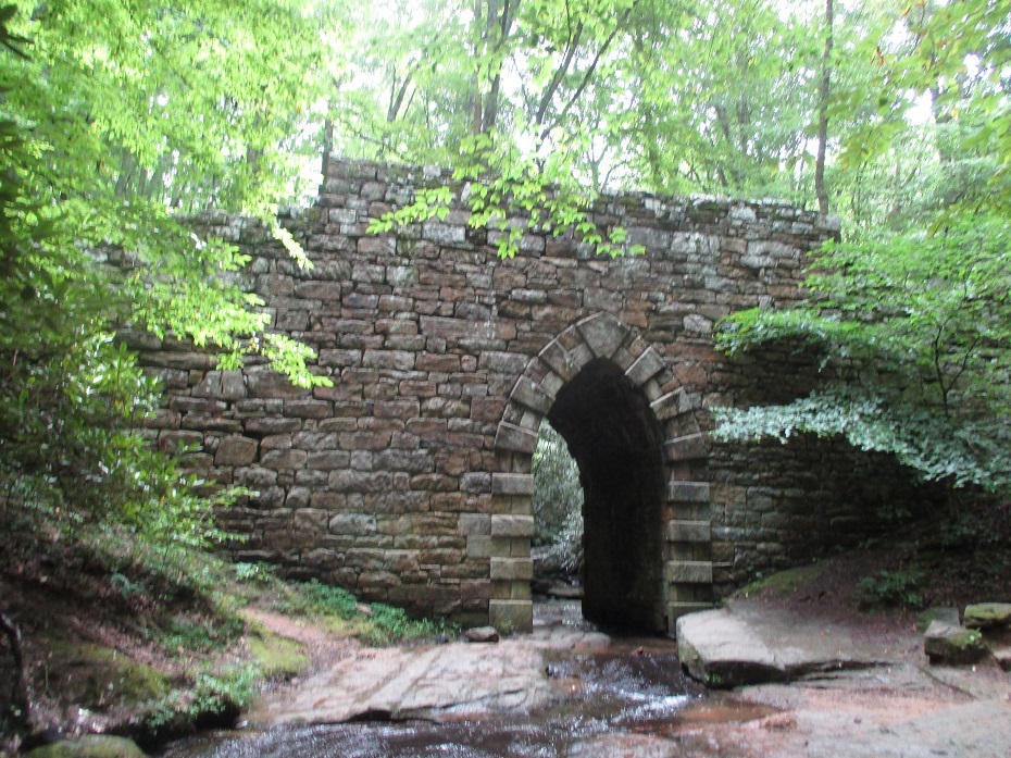
Poinsett Bridge, stretching
130 feet across Little Gap Creek, 24 feet in height, with
14-foot gothic arch, and constructed of stone without
mortar.
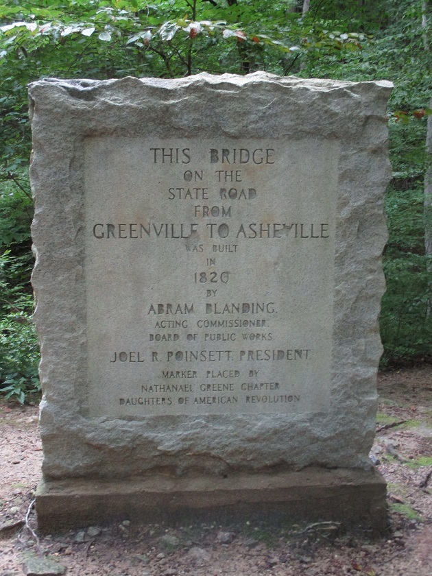
Historical marker at the
Poinsett Bridge.
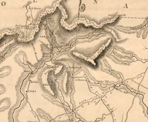
Portion of a map of Greenville
District, South Carolina, from Robert Mills' 1825 Atlas
of the State of South Carolina. The mountains to the
north are the North Carolina boundary. The roads going south
lead to Greenville. If you look closely, there is a bridge
over Little Gap Creek—what later would be called Poinsett
Bridge. To give a measure of scale, the distance from
Poinsett Bridge to the North Carolina boundary is four
miles.
Only Remaining Covered
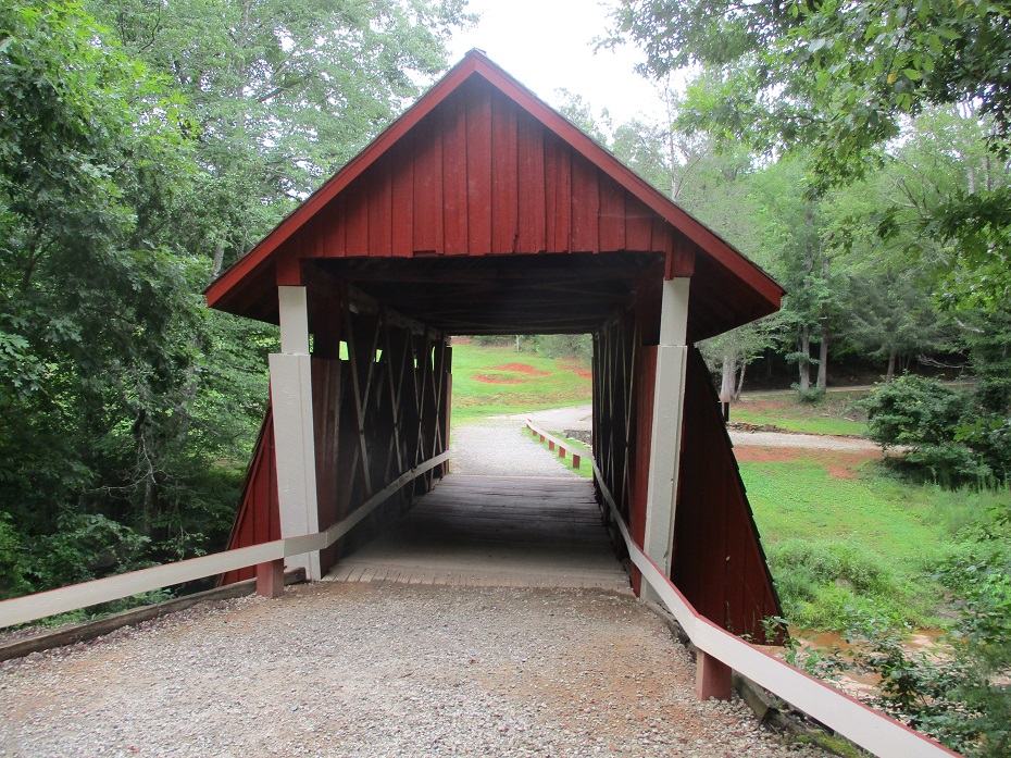
Bridge in South Carolina -- Campbell's Covered Bridge
Campbell's
Covered Bridge is located
just three and a half miles off of the Foothills Highway,
all on paved roads. It was constructed in 1909 and closed to
vehicular traffic in 1984. The bridge spans Beaverdam Creek,
is constructed of pine with a metal roof, measures 38 feet
long and 12 feet wide, and uses the rare Howe truss design.
It sits on a rock foundation with a concrete cap.
At one time South Carolina had 20 covered bridges;
today only this one remains.
Directions to the bridge are
online.
It was built by Charles Irwin
Wills, a talented local builder, and is named for Alexander
Lafayette Campbell, who operated a grist mill about 50 feet
downstream from the bridge (the gristmill remains can still
be seen downriver). It is now surrounded by a small park
with a nature trail nearly a mile in length. In the first
decade of the twentieth century this part of northern
Greenville County had four covered bridges; Campbell's
Covered Bride was the largest and most important one. It
connected a number of near-by rural communities and small
towns. Trips that might have taken a full day before the
bridge were reduced to about an hour after construction.
Before the bridge, the only crossing of Beaverdam Creek was
a narrow rock shoal.
Campbell's Covered Bridge was
listed in the
National Register of Historical Places
in 2009. The nomination form provides the specifications of
the bridge: "Campbell's Covered Bridge is a four-span Howe
truss bridge with counter braces. The two outer spans are 9'
long and the two inner spans are 8' long. Each truss is 4" X
8", and each counter brace is made from 2" X 8" pine boards
nailed together in an interlocking pattern. Vertical tie
rods called kingposts, made from 1" diameter iron rods, are
in between each span, tying the top and bottom chords
together. This method of truss construction absorbs and
transfers a passing vehicle's weight to the rock abutments
one each end of the bridge. The siding of the bridge
consists of 1" X 6" pine boards with 1" battens covering the
joints. Siding covers the three wooden buttresses that jut
out on each side of the deck, forming a triangular shape and
sheathed with cedar shakes. A gable roof of five-V
galvanized steel covers the structure. The bridge is open at
both ends, with a gap at the top between the siding and roof
to allow for air circulation. The deck is made from 2" X 6"
pine boards. The trusses are exposed on the interior of the
bridge."
Head on
view showing the road bed and some of the interior. The
primary reason for covering a bridge was to protect it from
severe weather. Unlike Poinsette Bridge, Campbell's Covered
Bridge is not haunted. However, picture it at night in the
1920s with an avenging angel of death driving a horse buggy
across the bridge. A scene from the 1981 horror movie A
Day of Judgment was filmed at this location with that
avenging angel coming out of the bridge to seek justice.

View of the
side of the bridge, with an abutment showing. The builder
allowed the truss ends to follow the natural lay of the land
and built the rest of the bridge to fit. As a result, and by
design, the bridge is neither square nor plumb.
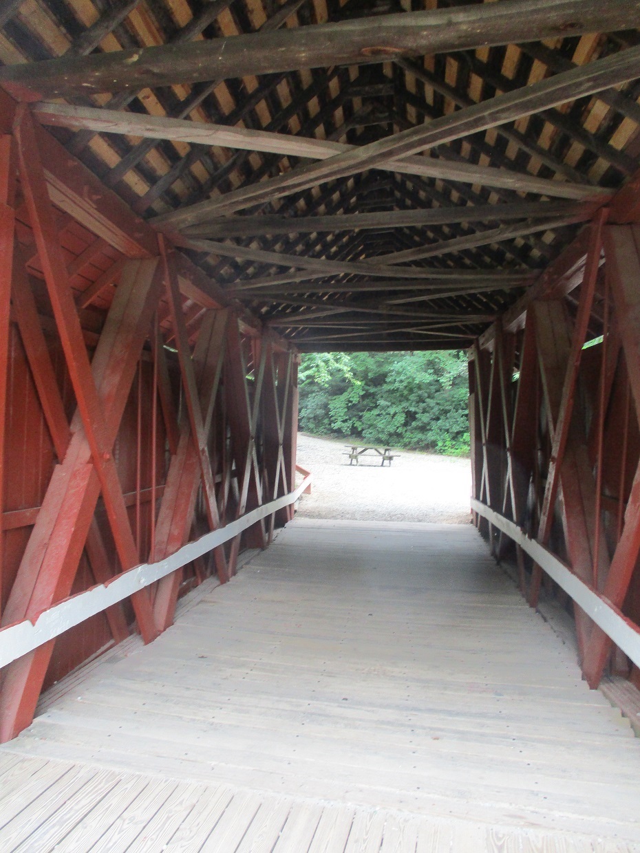
View of the
interior structure of the bridge, with exposed trusses,
consisting of wooden upper and lower chords, which are
linked together with sets of dual iron rods and wooden
braces and counter braces.

The bridge
is worthy of a state historical marker.
ad
Public Disclosure
Please Read
FTC has a law
requiring web sites to let their readers know if any of the
stories are 'sponsored' or compensated. We also are to
let readers know if any of our links are ads. Most are not.
They are just a way to direct you to more information
about the article where the link is placed. We have several ads
on our pages. They are clearly marked as ads. I think
readers are smart enough to know an ad when they see one but to
obey the letter of the law, I am putting this statement here to
make sure everyone understands. American Roads and Global
Highways may contain affiliate links or ads. Further, as their
bios show, most of the feature writers are professional travel
writers. As such we are frequently invited on press trips, also
called fam trips. On these trips most of our lodging, dining,
admissions fees and often plane fare are covered by the city or
firm hosting the trip. It is an opportunity to visit places we
might not otherwise be able to visit. However, no one tells us
what to write about those places. All opinions are 100% those
of the author of that feature column.